
Established in 1989, the Global Precipitation Climatology Center (GPCC) has been assigned by WMO/WCRP/GEWEX to collect, quality assure, process and grid world-wide in-situ data of measurements of rain and snowfall, collected by rain gauges. In doing so, the GPCC creates analyses based on data obtained from the GTS, through bilateral contacts with partner WMO National Hydro Meteorological Services, and from scientific and institutional precipitation data collections. A multifaceted quality control process is used, which includes harmonization of the station metadata (station identification), evaluation of redundant station reports, and quality assessment for the station reports (including manual checks for some data products).
As a result, the GPCC’s monthly products are based on the world-wide largest quality controlled data archive comprising more than 90,000 stations. Among those, 75,000 stations have series of 10 years or more. The data are interpolated on global grids of up to three resolutions (2.5°, 1° or 0.5°), and all data sets are referenced by DOIs (Digital Object Identifiers). This safeguards a version-controlled and long-term publication of the data and related meta information in a machine-readable format (netCDF) through the GPCC download gateway.
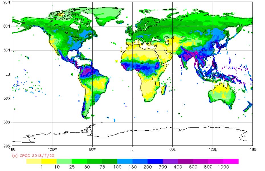
GPCC products serve a large spectrum of applications ranging from drought monitoring to providing reference information for calibration of satellite-based measurements and long-term global climate monitoring of variability and trends of land-surface precipitation. Moreover, the quarter-degree-resolving background climatology (Fig.1) is also used for precipitation maps used in school books.
Since 2012, GPCC has also been processing and developing new high-quality-analysis products based on daily precipitation data. Moreover, a semi-automated homogenization scheme has been introduced to regularly issue re-analysis products suitable for robust trend analysis. Hydro-climatological parameters issued using the same grid topology as the analysis products, allow generating derived products such as the globally applicable GPCC drought index.
The processing of historic daily data for the period 1988-2008 allows GPCC also to offer the combined rain gauge – single satellite-sensor-based daily precipitation product DAPACLIP, featuring a particular temporal stability and 1° resolution. The coverage of this data set is currently extended into the past of the 20th century through GPCC’s collaboration in the ERA_CLIM2 project, in order to provide an observational daily data set ready for verification of re-analysis data sets like ERA_CLIM.